 搜索
搜索

热门供应商
该产品暂无相关的供应商
PK的排行更多
- 台湾路昌 振动...
- 日本理音 测振仪...
- 日本理音 激...
- 美国康塔仪器 ...
- 北京拓必拓 微...
- 上海舜宇恒平 在...
- 荷兰Skalar...
- 德国德尔格 ...
- 北京拓必拓 超...
- 日本Kanoma...
最新更新的同类仪器更多


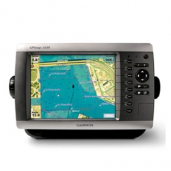
最新产品 > 物理分析仪器 > 大地测量仪器 > GPS>美国Garmin 航海导航GPS GPSMAP® ...
更新时间:2025-02-11 04:12:47 点击:336次
| 产品型号 | GPSMAP® 2008 |
|---|---|
| 参考报价 | 返回顶部 面议 |
| 基本规格 | |
| 产品类型 | 返回顶部 GPS |
| 品牌 | 返回顶部 美国佳明Garmin |
| 产地 | 返回顶部 美国 |
| 返回顶部 我来纠错(有奖) | |
| 技术参数 | |
| 防水防震 | 返回顶部 是(IPX7) |
| 数据传输 | 返回顶部 NMEA 0183 |
| 仪器尺寸 | 返回顶部 11.2" x 7.0" x 4.6" (28.5 x 17.8 x 11.7 cm) |
| 其他信息 | |
| 产品简介 |
硬件和性能: |
| 应用文章 | 返回顶部 此仪器尚未有相关文章 |
| 产品样本 | 此仪器尚未有相关样本 返回顶部 |
| 应用范围 | 返回顶部此仪器尚未有相关应用 |
| 用户数 | 返回顶部 此仪器尚未有用户数 |
| 技术创新 | GPSMAP 2008 chartplotter has sunlight readable and high resolution quality on an 8” SVGA (800 x 600 pixels) display, easy to flush-mounts or bail-mounts in your boat. Features designed specifically for professional fishermen at more affordable cost to larger display chartplotters. The 2008 also sports a built-in, worldwide basemap and simple, straightforward buttons and menus. You can add the optional BlueChart® g2 SD card for more enhanced map features. Except with English user interface (UI), the 2008 is the first Garmin chartplotter equipped with Asian language pack, including Traditional Chinese, Simplified Chinese, Indonesian Bahasa, Thai, and Myanmar. Navigate with Ease With just a few buttons and a simple, intuitive interface, the GPSMAP 2008 makes navigating virtually effortless. The GPSMAP 2008 has an SD™ card slot so you can add additional detailed maps worldwide without connecting to a computer. Add Sonar Where applicable, the GPSMAP 2008 can connect with a powerful sounder (GSD21) and dual frequency transducer that clearly paints depth contours, fish targets and structure whether you’re fishing in freshwater or off the coast. Capable of connecting to Garmin NMEA 0183 Intelliducer for various depth fathoming sensors. The GPSMAP 2008 is also CANet™ compatible, so you can share sounder data with another chartplotter on your boat. 返回顶部 |
| 最新动态 | 返回顶部 此仪器尚未有最新动态 |
| 相关视频 | 返回顶部 此仪器尚未有相关视频 |
| 相关耗材和配件 | 此仪器尚未有相关耗材和配件 返回顶部 |
| 相关仪器 | 返回顶部 此仪器尚未有相关仪器 |
| 网友评分 |
评分:
4星:0人 3星:0人 2星:0人 1星:0人 返回顶部 |
|
该产品暂无相关的供应商 |


- 网友评论:
- 已有0条评论